


On 3rd of June 2018, volcano Fuego erupted the second time that year; that day started from a strong explosion in the early morning. It was the deadliest recent event involving Fuego. This post may be the first one on WPD to show the aftermath of a modern volcano explosion - I mean mostly the bodies, of course.
Sections go as follows:
1. Time, place and how it begun. Includes videos recorded by the witnesses, and some maps and technical details.
2. Aftermath. What was left of the villages and people (and a few animals) living there. Both photos and videos showing the corpses (including animals).
3. Landscape. What was visible only from the air.
4. Photos or videos from the rescue operations. Includes cute animals, this time not dead - from a horse through dogs to cats (you have to open the gallery I linked) and even chickens rescued by the firefighters and police.
⠀TIME AND PLACE 
First, the basic map:

And location of the most important communities (click to enlarge, it's nearly 5 MB):

Summit elevation: 3763 m.
Fuego was characterized by a moderate activity during the first two days of June. In the early morning of 3rd of June 2018, there was a strong explosion. The ash plume rapidly rose to 6 km altitude (above the sea level, not above the volcano). Large pyroclastic flows travelled down three ravines, and into two communities: Sangre de Cristo and San Pedro Yepocapa (west flank). Thorough the day, more strong explosions happened, producing additional large pyroclastic flows in six ravines and causing devastating damage to numerous communities around the volcano.
Two views of the pyroclastic flows. Specifically: 8 km E of the summit and 7 km SE of the summit.


Now, two videos. I don't know their very exact location. In the first, the cameraman and the rest of people watching did a really dumb thing - but we have this video, at least 
A brave Guatemalan dad and son drove several times toward the ash cloud after the Fuego volcano eruption to help people get down to safer zones on Sunday (June 3). Adrian Larios told Reuters he and his dad drove up 13 times until they got all the people who couldn't move fast enough to escape the lava. A video filmed by himself showed his dad driving and urging people to get inside the car as other people ran downhill on the street.
Video of firefighters trying to drive away from an ash cloud. That escalated quickly 
Ash plume was fucking big.
The ash plume from a large explosion at Fuego on 3 June 2018 rose above the cloud cover to over 15 km altitude and was imaged by the Visible Infrared Imaging Radiometer Suite (VIIRS) on Suomi NPP at 1300 [1 PM] local time. Courtesy of NASA Earth Observatory.

Photo of what you've seen in a detailed map earlier.
The pyroclastic flows down the SE flank were especially devastating to the communities in their path, covering roofs and vehicles with ash and debris (figure 97-100) and killing scores of people. The communities of San Miguel Los Lotes about 9 km SE of the summit and El Rodeo (10 km SE), both in Escuintla Province, were severely damaged from the pyroclastic flows, with most of the fatalities and missing people reported from those communities.

On 3rd of June 2018, explosions stopped at early evening. Pyroclastic flow activity finally slowed down. Some communities had to be evacuated due to lahars - that's what is formed when the debris, ash and dirt mixes with water, creating a mudflows. On 4th of June, there were 5 to 7 weak explosions every hour, which means 'lower levels of activity'. Emergency was declared in all three provinces surrounding the volcano (Escuintla, Sacatepéquez and Chimaltenango). On 5th of June, there were 8 to 10 moderate explosions per hour, which resulted in increased number of the block avalanches. Two new pyroclastic flows led to evacuation of additional communities - seven in total - and closing Palín-Escuintla highway.
This photo was taken on 5th of June, 10 km SE of the summit, in El Rodeo community. It shows the additional pyroclastic flow.

⠀AFTERMATH 
Two videos, first one is small resolution and corpses are visible in the first part; second one shows digging the body from the rubble.
Title of this video mentioned looking for survivors, but seems there are corpses. CW here, there is rather stiff baby or toddler carried away in the beginning.
Unusually for the media, this time corpses were quite commonly depicted in the pictures, and not only by the agencies that usually show more gore than the others (e.g. AP).


It's harder to get photos with more corpses visible. I found this one on Facebook:

Other photos are scattered aroung the internet, including Documenting Reality. Some of them apparently were on Facebook, too.


Kids, news say they were from El Rodeo:


Duck, dog (in worse resolution) and a cow in affected zone:


Statistics from October 2019:
On 3 June 2018, Guatemala's 3,763-metre (12,346 feet) Fuego Volcano erupted, killing 201 people, injuring 27, and leaving some 260 people missing. The volcano emitted an eight-kilometre (five-mile) stream of hot lava and a dense plume of black smoke and ash that blanketed Guatemala's capital city and other regions. According to Guatemalan authorities, 12,823 people were evacuated from the affected area, of whom 1,398 remain in collective centres.
⠀LANDSCAPE 
La Reunión Golf Course and Residences on 7th of April 2017 and on 6th of June 2018:


San Miguel Los Lotes on 5th of February 2018 and on 6th of June 2018:


Drone view on El Rodeo community:
View from the helicopter (volume warning) on 4th of June:
Few clips from The Guardian, some of them is aerial footage:
⠀RESCUE OPERATIONS (PHOTOS/VIDEOS) 
I will put links to galleries here, as otherwise scrolling this post would take really long.
Carrying away the wounded:


Very nice gallery on The Atlantic site.
Some photos from animal rescue:
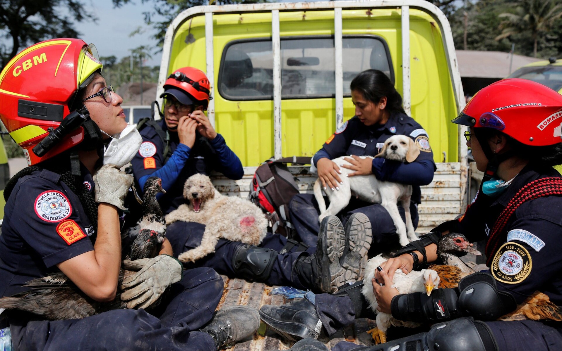


More photos showing animal rescue!
Wholesome video of firefighters with rescued hen and her baby chicks:
⠀SOURCES 
https://volcano.si.edu/showreport.cfm a really detailed summary of the activity of the volcano Fuego in 2018, on a website of The Smithsonian Institution's Global Volcanism Program (GVP)
https://www.nytimes.com/interactive/2018/06/07/world/americas/guatemala-volcano-eruption.html amazing map and 'before and after' photos for comparision!


 Slavshit

 Sandshit

Jump in the discussion.
No email address required.
This was probably one of the most detailed posts ever.
Absolutely horrendous idea to think about, imagine getting burned by fucking lava.
I don't get why people even built homes close to volcanoes.
Anyways you have my upvote because HOLY SHIT!
Jump in the discussion.
No email address required.
I have to admit, this was far more creepy than 'normal' gore (blood and guts). It was not burning by lava, it was suffocation and being baked alive.
And about the details: https://watchpeopledie.tv/h/other/post/73879/david-parker-ray-his-toy-box this is probably the most detailed post on WPD, also the longest. Topic is not accidental
Jump in the discussion.
No email address required.
More options
Context
Land near volcanoes are typically very fertile as result of the elements in the ash. My guess is that they are probably farmers or their work requires fields of some description.
Jump in the discussion.
No email address required.
More options
Context
As an Icelander, I don't know why people build their homes near volcanoes, either. But at least we have an excuse, since the entire country is basically one giant volcano, and also situated directly on top of the Eurasian Plate lol.
Jump in the discussion.
No email address required.
More options
Context
More options
Context
the pic with the lil ones huddled together got me. poor lil mites
Jump in the discussion.
No email address required.
More options
Context
Amazing post
Jump in the discussion.
No email address required.
More options
Context
Do the corpses turn into stone? Sorry if it's a stupid question! Really amazing post
Jump in the discussion.
No email address required.
They don't: https://www.realclearscience.com/articles/2021/03/27/what_happens_to_a_body_caught_in_a_volcanic_eruption_770078.html
Jump in the discussion.
No email address required.
Thanks for the article
Jump in the discussion.
No email address required.
More options
Context
“This shrinkage can be as much as 30%.”
… 1% is enough for me, thank you very much.
Jump in the discussion.
No email address required.
More options
Context
I think he somewhat exaggerates how long has it been since Roman Empire.
Jump in the discussion.
No email address required.
Ugh this is Pompeii it's so surreal
Jump in the discussion.
No email address required.
More options
Context
More options
Context
More options
Context
More options
Context
As someone who lives in Iceland and gets to experience our micro-doomsday events every couple years or so, pyroclastic flows and their fumes are no fucking joke. Great post, by the way.
Jump in the discussion.
No email address required.
More options
Context
Volcaner goed booom! Many sad, much ded. Rip in pieces.
Jump in the discussion.
No email address required.
More options
Context
Good as always
Jump in the discussion.
No email address required.
Will be even better. I mean, it's already bad, but I promise, the rest of information will make it even worse
Jump in the discussion.
No email address required.
More options
Context
More options
Context
Thanks
Jump in the discussion.
No email address required.
More options
Context
Snapshots:
ghostarchive.org
archive.org
archive.ph (click to archive)
ghostarchive.org
archive.org
archive.ph (click to archive)
ghostarchive.org
archive.org
archive.ph (click to archive)
news say:
ghostarchive.org
archive.org
archive.ph (click to archive)
ghostarchive.org
archive.org
archive.ph (click to archive)
ghostarchive.org
archive.org
archive.ph (click to archive)
ghostarchive.org
archive.org
archive.ph (click to archive)
ghostarchive.org
archive.org
archive.ph (click to archive)
ghostarchive.org
archive.org
archive.ph (click to archive)
ghostarchive.org
archive.org
archive.ph (click to archive)
ghostarchive.org
archive.org
archive.ph (click to archive)
ghostarchive.org
archive.org
archive.ph (click to archive)
ghostarchive.org
archive.org
archive.ph (click to archive)
Very nice gallery on The Atlantic site:
ghostarchive.org
archive.org
archive.ph (click to archive)
ghostarchive.org
archive.org
archive.ph (click to archive)
ghostarchive.org
archive.org
archive.ph (click to archive)
ghostarchive.org
archive.org
archive.ph (click to archive)
ghostarchive.org
archive.org
archive.ph (click to archive)
More photos showing animal rescue!:
ghostarchive.org
archive.org
archive.ph (click to archive)
Jump in the discussion.
No email address required.
More options
Context